
- The Largest of the Tennas Lakes
The Old McKenzie Highway (Ore Hwy 342) has been closed for the biggest part of the last two summers so it opened up again a couple weeks ago, I decided I need to go up and check it out. The Old McKenzie Highway is a very scenic but a very winding road over the Cascade Mountains and across the famous lava beds.
As a friend of mine had been up there last weekend and mentioned there were a few wildflowers still in bloom at high elevations I knew one of the best places to find them might be on Mt Scott. Mt Scott is a very weathered cinder cone and rises about 800 feet above a high plateau. A large lava flow lies just to the east a couple miles so I decided to do a loop that would take in Benson Lake, Tennas Lakes, Mt Scott then go east to the trail along the lava flow back down to Hand Lake and Scott Lake.
I got and early start so I arrived at the trail head at Scott Lake about 8:30. It was still pretty cool and temperatures were still in the low to mid 40’s. Brrr….. Those shorts and short sleeved shirt was feeling pretty light but what’s the heck, I’ll just walk a little faster going up the hill.
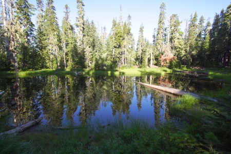
The trail climbs gentle but steadily for about a mile and a half thru the lodge pole pine and white bark pine, until you come to Benson Lake. The cool calmness of the early morning left a mirror reflection of the deep blue lake. Benson is one of the largest lakes in a group of lakes that lie southwest of Benson. It seem like there a little lake in every depression. I didn’t see a single person camping at Benson the the stillness and calmness of the lake was stunning.

Benson Lake - Morning Reflections
After stopping long enough to take a few picture I start up the trail to Tennas Lake. I was amazed that with the coolness of the morning I didn’t see a single mosquito. It’s just a little over a mile from Benson Lake to Tennas Lakes. It was warming by now and I started seeing more mosquitoes.
A Mosquito Pond
A wooden sign mark the trail into Tennas Lakes but the trail kind of runs out when you get to the first of the 4 or 5 lake that make up this group. The first lake is the largest lake and I stopped to take a nice pano ( See the one at the beginning of this blog) and apply the first of several coats of mosquito repellant.
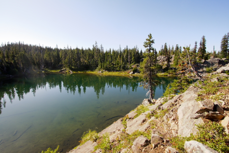
Tennas Lake Rocky Shore
There were a couple parties camping by a couple of the lakes, so I quietly skirted the camps as I found my way over to two more lake separated by a rocky ridge. From the highest rock you have a nice view of both lakes and Mt Scott. A little ways to the west is a 100 foot sheer cliff. This offers some nice views of the upper Linton Creek Drainage basin.

Tennas Lakes - Twin Lakes

Tennas Lakes - There's another Lake!

Mt Scott from Tennas Lakes
After the look at Mt Scott I was ready to hit the trail for it. From Tennas Lakes the trail climbs a little more steadily and in about another mile or so you come to a fork in the trail. A very rickety wood sign post is propped up and point to the trail to the left being the trail up Mt Scott. From here it’s a half mile with about a 500 foot climb or more. I began to see a few wildflowers as I gained elevation and started getting some nice peek of Mt Jefferson to the north. The trail hooks around the north this if the hill and by the time you get to the top you come in from the west.

Wildflower Meadows near top of Mt Scott
The open meadows near the top were beautiful and many late wildflowers were still in bloom with butterflies flitting around. There are great views of the other Cascade peaks and I could easily see the Three Sisters, The Husband, Diamond Peak and maybe that was Crater Lake Rim thru the haze. Looking off the North side I could see Mt Washington, not far away then Three Fingered Jack, Mt Jefferson and just a little too the left Mt Hood. On the grassy summit are the remains of an old fire lookout. Just the concrete foundation blocks are left. The USGS survey control point is gone but one reference brass cap still remains.
Looking North:

Top of Mt Scott looking North

Hoodo Mtn, Three Fingered Jack, Mt Jefferson, Mt Hood

Mt Washinton from Mt Scott
Looking South:

Three Sisters from Mt Scott
I took some time to take pictures of the flowers and butterflies before getting ready for the next leg of my journey.

Wildflowers


Butterflies


It was almost noon by now so I knew I needed to be on my way again. I followed the trail back down to the fork in the trail. There was a tree down over the trail and it didn’t look like it had much use. As I started down it I did notice on set of horse track and one set of boots. This trail descended steadily and it went thru several areas of blow-downs that had been cut out of the trail maybe 3 or 4 years ago. No recent maintenance had been done. It was a good 2 to 21/2 mile to the next fork in the trail. I knew I wasn’t far from the lava flow now. As I continued southeasterly there was a quarter mile or so section that way very deeply rutted and in places it was almost waist deep. At bout a ½ – ¾ miles I came to the old lava flow. I knew now that it would take me down to Hand Lake. As I walk south along the lava flow I got some great views of the Three Sisters Mountain so 15-20 mile away.

Lava Flow - Three Sisters
When I got near the bottom of the lava flow I could see Hand Lake through the trees. The trail however didn’t go down there but stayed a ways up on the ridge. I was hot so I broke down through the woods to the lake.

Hand Lake
Hand Lake is very shallow. It looked a little deeper near the lava flow so I decided to take a quick dip and cool off. It was quite warm for being 5000 feet and it wasn’t the least bit cold. When I was finished I could see the Hand Lake Shelter about a quarter mile to the west. I walked over to the shelter along the lake and soon found the solid shelter structure at the edge of a grassy meadow. After looking it over a bit I decided it was time to head for Scott Lake and the car.

Hand Lake Shelter

Hand Lake from near the Shelter
There was a good trail leading west from the Shelter so I followed that in hope I’d run into the trail to Scott lake. A half mile later I ran into some people hiking in and they told me this trail went back down to Hwy 242 and not Scott Lake. I went back to the Shelter and this time I notice a faint track through the grass leading to the ridge where I had left the trail.
The 1 ½ mile trail from Hand Lake to Scott Lake is very flat. It was a rather pleasant walk and I ran into a few other people hiking as I got closer to the Scott Lake. Scott Lake is a very popular place to camp as the lake is very swimmable and it offer a lot of great scenery and hiking. It looked like almost every camp site was taken and when I got back to the car, the trail head parking area was full too.

East Scott Lake

Scott Lake
This had been a beautiful hike with near perfect weather. A few less mosquitoes in places would have been nice but all things considered a very pleasant hike. Enjoy the pictures and I hope you’ll get a chance to hike this yourself someday.
Dennis
